


East Cliff Drive Parkway
and Bluff Protection Project
Location: Pleasure Point Area of East Cliff Drive between 32nd Avenue and 41st Avenue
Project Manager: Melissa Allen 
Background and History: Failure of the cliffs along East Cliff Drive occurred periodically over the past several decades. It became clear that continued failures would ultimately undermine the road, threaten vehicle access for residents, limit pedestrian and bicycle access to the cliff and beach, and sever major underground utility lines. The County and area residents were able, through the assistance of then-Congressman Leon Paneta, to secure funding for a Corps of Engineers study of cliff stability issues in the area. That study, completed in 1994, concluded that cliff stabilization was critically needed and qualified for federal funding.
In the meantime, significant additional cliff failures occurred in early 1994, resulting in the need to restrict traffic on East Cliff Drive to one-way and to repair the bluff and road near Larch Lane. Because of the problems this restriction caused, a citizens’ task force was established to evaluate the issues further. The consensus was, given the scenic and recreational attraction of the area for the entire community as well as coastal visitors, that walking and bicycling along the cliff should be made as safe and enjoyable as possible; that one-way traffic should be maintained with vehicular traffic shifted as far away as possible from the cliff edge; and that overall traffic circulation should encourage through-traffic to remain on East Cliff Drive. Unfortunately, these improvements could not be constructed without first stabilizing some sections of the coastal bluff. Based on the task force recommendations, the Board of Supervisors directed staff in 1995 to pursue funding for a cliff stabilization project to facilitate the community’s future vision for the area.
While exploring options for protecting and enhancing public use of this section of East Cliff Drive, staff has focused efforts on providing a generous public walkway and bike path along the road and stabilizing the underlying cliffs. The wall portion of the project (between 32nd Avenue and 36th Avenue, and at the end of 41st Avenue) includes the construction of two colored, sculpted, concrete "soil-nail" walls, two new access stairways to the beach, and the removal of concrete rubble on the beach. The upper bluff improvements, which are a separate component, will consist of a pedestrian path, bicycle path, landscaping, safety railings, and improvements to the small, neighborhood park at 32nd Avenue.
After the preliminary designs were completed and presented to the community in December of 2000, an application for a Development Permit for the bluff top improvements was submitted to the Planning Department. As part of the permit process a joint Environmental Impact Statement/Environmental Impact Report (EIS/EIR) was prepared for both the bluff top and the cliff stabilization work.
An application for a Consistency Determination to the California Coastal Commission by the US Army Corps of Engineers for the stabilization work resulted in an objection by the Commission and Final Findings were adopted at the January 2004 meeting. Meanwhile, repairs to three cribwalls in the area were completed in the fall of 2004 under an emergency permit (See East Cliff Crib Walls Emergency Repair Work).
After some project revisions and additions to the EIR, the County Board of Supervisors approved the project Development Permit application on March 20, 2007 and certified the Revised Final EIS/EIR. The Final Environmental Impact Statement and Report can be viewed online at the Planning Department website http://www.sccoplanning.com/pdf/env/eirecliffseawall/toc.htm.
The project was presented to the California Coastal Commission at its December 2007 meeting and received unanimous approval for the County's permit application. The Commission staff report can be viewed at their website under the December 13, 2007 hearing date, Items 13a and 14a by visiting the following web location http://www.Coastal.ca.gov/meetings/mtg-mm7-12.html. The Redevelopment Agency and Public Works have obtained all required permits for this project.
This project consists of two phases of work. The first phase has been completed and includes bluff stabilization with sculpted soil nail walls between 32nd Avenue and 36th Avenue and a section of bluff at the end of 41st Avenue, two replacement stairways and one new beach access stairway, and beach riprap and rubble removal. The second phase now under construction includes a new pedestrian/bicycle path up to 16' wide, additional landscaping and replacement parking for the entire section of the one-way road between 32nd Avenue and 41st Avenue, and a public restroom for the Pleasure Point Park. These improvements are planned as part of the proposed Monterey Bay Sanctuary Scenic Trail as it proceeds through the Live Oak area between the cities of Santa Cruz and Capitola.
Project Status:
Phase 1 - Construction of the bluff protection structure between 32nd and 36th Avenues and at the Hook has been completed. Construction of the bluff protection portion of the project began in early summer 2009 and was completed in November 2010. That construction included removal of riprap and concrete rubble from the beach from Pleasure Point Park to 36th Avenue and at the Hook; new beach access stairs at the park at 32nd Avenue & Pleasure Point Drive which opened in December 2009; construction of replacement stairs near 36th Avenue which were completed mid 2010, and replacement stairs at the Hook which were opened to the public in October 2010. To view bluff construction site plans click here. For more information and photos see Projects Under Construction.
Phase 2 - Roadway and pedestrian improvements are following now that the bluff stabilization work is complete. Local consultants Whitson Engineers prepared design plans for the parkway portion of the project. Two additional Community Meetings were held in spring 2009 and fall 2010 to discuss the Pleasure Point Park design, Monterey Bay National Marine Sanctuary interpretive exhibit, to present the latest Parkway plans, get input on safety railing fence options, and discuss the project schedule. Click on the following links to view the Parkway Concept Design and Park Concept Exhibits. Though there will be new improvements at the park including a public restroom with outdoor rinse showers, all of the existing community placed art features will be retained and reinstalled with the new design and replaced after construction is complete. The construction contract for the parkway portion of the project was awarded by the Board of Supervisors in May 2011 to Granite Rock Company, Pavex Construction Division. Notifications for the start of construction were sent out in late May and early June. Construction will begin in July 2011 and is expected to be complete in the summer of 2012.
To view construction plans, click here.
Also, for a current rendering of the Pleasure Point Park, please click here.
Click here to view Start of Construction Notice.
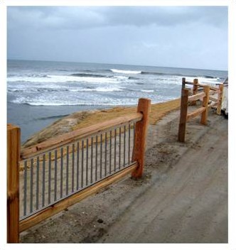
After considerable public discussion in the fall of 2010 regarding the final designs for the safety railings, which are necessary in places where the pedestrian pathway is directly adjacent to the steep bluff cliff, the Redevelopment Agency posted simulations of two alternative railing styles on this webpage for public input. Of the two final style options, more members of the public preferred the railing with a 42" wood frame design with thin vertical steel bar inserts. In locations where safety railings are not necessary, traditional wood split rail fencing will be used.
As the contractor begins this project, Supervisor John Leopold will be hosting a community meeting this Monday, August 8th, at the Simpkins Swim Center starting at 7 pm to review with the community the work that will be done over the coming months.
For questions, please call Melissa Allen, Project Manager, at 454-2280, or Joel LaCagnin at 454-2160.