


Moran Lake Water Quality Study & Conceptual Restoration Plan
3. Lagoon and Watershed Hydrology
Moran lake is a coastal lagoon. In general terms a coastal lagoon is a body of brackish, marine or hypersaline water impounded by a sandy barrier and having an inlet connecting with the open ocean. Each coastal lagoon differs from all others. These differences fundamentally involve size, shape, tidal range, runoff of tributary streams, climate of the area, number and size of inlets and kind and amount of sediment available. Difference in water movement, chemistry, geology, and ecology result from these basic factors Phleger, 1981).
Using a physiographic classification of estuaries developed by Fairbridge (1980), Moran Lake is best described as a blind estuary with an ephemeral bar that develops in the dry season, creating an inland stagnate pool. Based upon a classification system developed by Kjerfve and Magill (1989), characterizing the type of channel connecting estuaries to the ocean, Moran Lake is a restricted lagoon connected to the ocean by an enclosing barrier. Barrier (bar) built estuaries, such as Moran Lake, occur where barriers enclose coastal embayments, forming extensive, shallow lagoons (Trenhaile, 1997).
Very small or “pocket” lagoons, such as Moran Lake, frequently occur at the seaward end of a stream, which has a small drainage basin and thus limited amount of runoff. Where the rainfall is seasonal, the inlet of such a lagoon is open during the rainy season and is closed by wave action and long-shore drift during the dry season. Under natural conditions these lagoons have significant water exchange with the open ocean by seepage through the porous sandy barrier (Phleger, 1981).
3.1 Historical Drainage and Morphology
Prior to development along the Santa Cruz County Coast, five coastal lagoons existed within the Live Oak area of Santa Cruz: from west to east, Wood’s Lagoon, Schwan Lake, Bonita Lagoon, Corcoran Lagoon, and Moran Lake. All of these lagoons have been impacted by urbanization, and only Corcoran Lagoon is considered to be functioning in a relatively ‘natural state’. In 1961 Wood’s Lagoon was expanded and converted into the Santa Cruz Yacht Harbor, at which time dredge and fill materials from the project were placed in Moran Lake, dramatically altering the lagoon landscape. The following section describes the hydrologic processes occurring within Moran Lagoon, at the inlet and on the beach, prior to 1961 and then following the construction of the Yacht Harbor.
3.1.1 Lagoon Hydrology Prior to Yacht Harbor and Coastal Development
Beach Form and Shoaling.
The beach at Moran Lake is one of many ‘pocket beaches’ along the Santa Cruz coastline. At low tides, prior to extensive development in the Live Oak Area, the development of the Yacht Harbor, and residential developments on East Cliff Drive, it was possible to walk from the Moran Lake beach to Lighthouse Point, on West Cliff Drive, approximately 4 miles north of Moran Lake. Based upon a review of historical aerial photos and observations of naturally functioning lagoon systems in relatively undisturbed drainage systems, the evolution and seasonal fluctuation of the Moran Lake beach in a natural setting can be hypothesized.
Beginning in late winter and early spring of each year, ocean waves would cause sands to shoal up on the beach forming an ephemeral bar blocking the entrance to the lagoon. The size and steepness of the sand berm would increase through the spring and summer until late fall or early winter when high tides and freshwater flows in the lagoon would breach the sand berm. A sinuous channel would form on a rather broad beach, snaking between the cliff boundaries on the east and west side of the beach. This channel would connect the lagoon to the sea until early spring when sands would again accumulate in the channel and the ephemeral bar would rebuild and block the lagoon entrance. Flushing of salt water into the lagoon would occur periodically throughout the year (but more often during winter-early spring), generally during high tides, or spring tides (Spring tides occur when the moon, sun, and earth are in line, during the full moon or new moon cycle.), when water would overtop the beach berm.
Inlet Morphology and Hydrodynamics.
Prior to 1961, the inlet morphology, or channel geometry of Moran Lake was likely determined by frequency and volume of tidal events. These important tidal events are defined as the tidal prism; a volume of water in a tidal system contained between two defined tidal datums (low and high tides) (PWA, 1995). Similar to bankfull flows in river channels, the tidal prism in estuary and lagoon systems is influential in forming persistent channel characteristics in tidally influenced systems. The tidal prism or volume of water entering and leaving the natural inlet establishes the equilibrium cross sectional area, width, and depth of tidal channels and inlets. The size or cross-section of an inlet is a function of the amount of water, which flows through it due to tidal prisim and amount of streamflow.
For a short period of time, usually in late October, early November after the beginning of winter storms and prior to the breach of the ephemeral bar, water in the lagoon was highly stratified. Low density freshwater from stormwater runoff formed a lens over the saltwater accumulated behind the sand berm during the summer months. During this period of time, wind processes likely provided the only mixing mechanism between the two layers.
In December and January, once the ephemeral bar breached and the lagoon received freshwater and tidal inputs, Moran Lake became somewhat less stratified, or partially mixed.
The lagoon became non-stratified or fully mixed when: (i) there was no or little flow from freshwater inputs causing the lagoon to become primarily filled with saline water, (ii) low tides coincided with large stream inputs causing high contributions from freshwater with little or no flow from the ocean, and (iii) prior to large freshwater inputs and breaching of the ephemeral bar, the lagoon probably experienced a prolonged period of stagnation becoming saline, or possibly hyperhaline. ( Hyperhaline refers to waters with a concentration of salt exceeding the ionic content of seawater with an ocean source.)
Many of these same processes continue today, albeit on a smaller lagoon.
Lagoon Opening and Closure.
Lagoon opening and closure typically occurs on two different time scales. River flooding is the major natural determinant of inlet conditions on time scales longer than a few years. Over short time periods, ranging from a few months to several years, inlet status is primarily determined by the available tidal prism and littoral sand transport. Results of long-term studies of coastal lagoons in southern California show that natural inlets may remain open 34% of the time. The tendency to remain open is vastly smaller during years of dry weather (12%) versus times of above-average rainfall (66%) (Elwany, et. al., 1998).
Historically, the typical inlet opening and closing sequence at Moran Lake, prior to its modifications, began when a major river flood scoured the lagoon and inlet channels. During severe winter storms flood flows would have most likely scoured the main channel to an elevation well below the equilibrium depth that could be sustained by the maximum available tidal prism. Through the remainder of the year littoral-drift sand, washed into the inlet by tidal processes and wave surges, rapidly filled the entrance and exterior portions of the channel. Then by late fall the inlet would be filled with sand to near the equilibrium depth.
When there were periods of drought or extremely low flows the lagoon would remain closed. Exceptions would occur during unusually high tide events, when large waves temporarily overtop or breach the beach berm.
3.1.2 Watershed Hydrology and Drainage System
Prior to development in the Moran Lake watershed the hydrology and landscape were very different from what they are today. The Moran Lake watershed has a southern orientation, and prior to the installation of drainage infrastructure in the 1980s, which decreased the extent of the Moran Lake watershed by approximately 180 acres, it extended north of Highway 1 between the Rodeo Gulch and Soquel Creek watersheds. Prior to current development the watershed was likely well vegetated, with a high infiltration capacity. The channels were able to migrate and meander within the watershed. The watershed consisted of open grasslands and forested coastal terrace areas with ephemeral tributary streams entering Moran Creek, the principal tributary to Moran Lake.
3.2. Current Drainage and Morphology
Between 1961 and 1963, dredge material removed from Wood’s Lagoon for the development of the Santa Cruz Yacht Harbor was deposited in Moran Lake, effectively reducing the surface water area of the lake from approximately nine acres to five acres. At this same time a 7-foot diameter culvert was installed at the lake outlet, approximately five feet above the mean high tide level, blocking the lagoon inlet and transforming the coastal lagoon into an inland lake. In 1981 the 7-foot diameter culvert was replaced with the existing box culvert beneath East Cliff Drive. The bottom (invert) of the box culvert was set at one foot below mean sea level.
Another significant change in the Moran Lake watershed was the transformation from open grassland and forested coastal terrace, to a rural farming community, and then into high density residential and commercial-industrial land uses. The result of these land use changes greatly increased the impervious surface area in the watershed, altering the hydrologic response, timing, volume, and quality of stormwater entering Moran Lake.
3.2.1 Lagoon Hydrology
Beach Form and Shoaling.The current beach form and shoaling processes function similar to historic processes. The Cabrillo College Geology and Oceanography Department has been monitoring the seasonal fluctuation of beach profiles along the Santa Cruz County coastline, including the beach at Moran Lake for several years. Monitoring data provided by the Department (D. Schwartz, personal communication 2003) showing monthly beach profiles for the 2001 to 2002 season are presented in Figure 3.1. The zero elevation datum on the y-axis represents the elevation of East Cliff Drive, with distance from East Cliff Drive towards the ocean on the x-axis.
Figure 3.1 depicts how the sand on the beach fluctuates seasonally. Beginning in the late winter and early spring sand accumulates on the beach and forms an ephemeral bar across the Moran Lake inlet. The elevation and accumulation of sand on the beach continues through spring until late fall, with saltwater associated with high tides occasionally overtoping the ephemeral bar and entering Moran Lake. Based on discussions with Dave Schwartz, Oceanography Professor at Cabrillo College, in some years the elevation of sand on the beach exceeds the elevation of East Cliff Drive, with the amount and steepness of sand on the beach reaching its peak in the fall months. The graphical data also shows how the first large storm in the late fall or early winter, combined with large wave energy, erodes the ephemeral bar and opens Moran Lake to the ocean. Depending on storm and tide patterns, sand elevations fluctuate throughout the winter. During this time the lagoon bar remains open to the ocean, until early spring when the ephemeral bar closes.
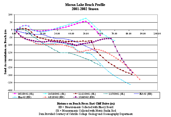
Figure 3.1 Moran Lake Beach Profile, 2001-2002 Season
While the connection remains open, storm surges and waves entering the lagoon carry sediment, primarily sands, that are deposited within the lagoon. At the time of this investigation, deposited material entering the lagoon formed shallow sand bars to the north of the box culvert, though it is anticipated the location and volume of these deposits varies seasonally and annually. The accretion of these sediments within the culvert and on the beach over numerous tidal cycles, eventually rebuilds the beach barrier blocking the connection between the lagoon and the ocean.
From aerial photographs it appears the width of Moran Lake Beach has diminished since the 1900s, possibly due to a combination of influences including the construction of the Harbor jetty and residential development adjacent to the beach.
When the Harbor jetty was built in 1961 it disrupted long shore sediment transport north and south of Wood’s Lagoon. Sand accumulation on beaches north of the jetty increased while sand accumulation decreased on southern beaches, such as Moran Lake Beach. Recent changes in timing of harbor dredging and spoils deposition location south of the harbor may increase the amount of sand at Moran Lake Beach. However, more study is necessary to assess the relationship between the management of dredge material from the harbor and changes to the coastline south of the Harbor.
Residential developments and seacliff riprap placed to the north and south of Moran Lake Beach may also have limited sand production and accumulation. Though the Moran Lake Beach was historically small, these developments and the diminished beach size have restricted the development of the lagoon channel on the beach side of East Cliff Drive. Without these changes, a beach side lagoon similar to those existing at Corcoran or Schwan Lake would be expected at Moran Lake.
Lagoon Boundary and Tidal Inlet Structure.
Development and infrastructure, such as the construction of East Cliff Drive has confined the lagoon to a relatively fixed configuration. The roadbed and adjoining upland areas are physical barriers to geomorphic changes in the shape and surface area of the lagoon.
The existing box culvert under East Cliff Drive seasonally connects Moran Lake with the Pacific Ocean. The box culvert is 71.6 feet long with 21-foot long wing walls extending into the lagoon. On the ocean side, the culvert extends 12 feet onto the beach and wing walls extend approximately 15 feet on either side of the culvert walls. The depth and width of the box culvert under East Cliff Drive is approximately 12 feet. The box culvert has a fixed bed at an approximate elevation of 1 foot below mean sea level. The box culvert is a grade control structure and limits the depth of the inlet channel to the invert elevation of the culvert.
Lagoon Morphology and Circulation.
Water and salinity levels in Moran Lake vary seasonally based on a cycle of inlet blocking, tidal flushing, and freshwater inflow. Circulation and salt/freshwater mixing patterns depend upon seasonal fluctuations of the beach and tidal inlet, stream flow and climatic conditions. Over the course of this study, four mixing patterns were observed within the lagoon: highly stratified non-mixed, partially mixed, non-stratified freshwater, and non-stratified saltwater.
Highly Stratified Conditions.A highly stratified non-mixed regime was observed within Moran Lake during the first flush event of the season. At the time of the event on October 31, 2003, the ephemeral bar at the lagoon inlet had not been breached and limited interaction between the lagoon and ocean was possible. Rainfall-runoff entering the lagoon created a lens of freshwater above higher density saltwater that had accumulated during the summer months. The density difference between the fresh and saltwater and the lack of physical mixing by tides or winds prevented significant mixing between the two layers. Water quality measurements of salinity and conductivity, indicators of salt or freshwater content, clearly show the stratification of the salt and freshwater. Figure 3.2 shows the lagoon under highly stratified conditions with the transition between saltwater at the lagoon bottom and freshwater at the top. At the lagoon bottom from zero to six inches the water has a salinity of 29.6 parts per thousand (ppt) and a conductivity of 35.6 microSemens (mS). At the water surface the fresh stormwater has a salinity of 0.7 ppt and a conductivity of 0.96 mS.
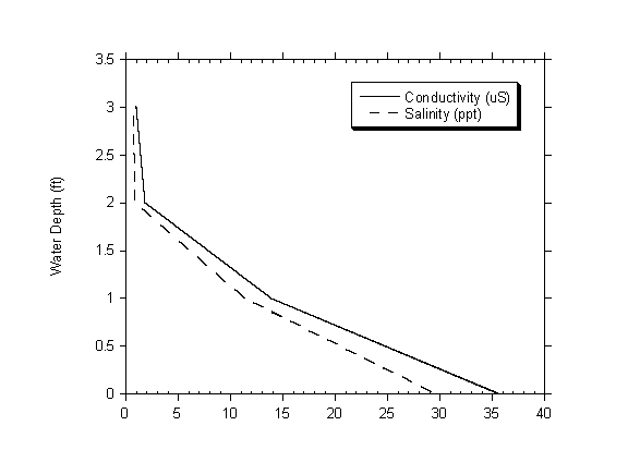
Figure 3.2 Summary
of Conductivity and Salinity Measurements Collected During the First Flush
Event
on October 31, 2003 from Site 2
A moderately stratified mixing regime was observed when the ephemeral bar breached, and the beach profile was not low enough to allow a continuous connection between the lagoon and ocean. Figures 3.3 and 3.4 show the lake and the channel on the beach when ocean and stormwater can enter the lagoon.
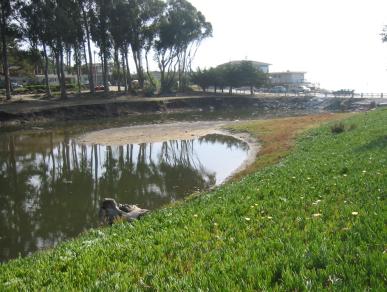
Figure 3.3 Moran Lake After Ephemeral Bar has Breached and Lagoon is Partially Mixed – November 12, 2003
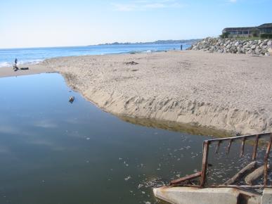
Figure 3.4 Moran Lake Beach After Ephemeral Bar has Breached and Lagoon is Partially Mixed – November 12, 2003
Non-Stratified Freshwater Condition.The lagoon is non-stratified and primarily filled with freshwater when the sand bar elevation has dropped below the bottom or bed elevation (invert) of the box culvert. When the sand bar drops below the invert of the culvert stream flow does not backup and pond but flows through. In this condition the lagoon is functioning as a stream channel. When the water levels were low in the lagoon, it revealed fine-grained silt and clay sediments on the bottom of lagoon basin. Figures 3.5 and 3.6 shows Moran Lake and the channel on the beach during a low tide when the water in the lagoon is freshwater.
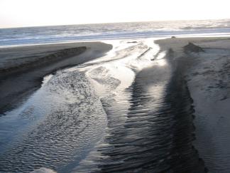
Figure 3.5. Lagoon Outflow Non-Stratified with Primarily Freshwater Flow – February 2, 2004
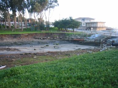
Figure 3.6. Moran Lake when the Lagoon is Non-Stratified with Primarily Freshwater Flow – February 2, 2004
Non-Stratified Saltwater Condition.The lagoon is non-stratified and primarily saltwater when the ephemeral bar reforms across the lagoon inlet and the stream flows are low occurring typically in later spring. The bar closure limits the interaction between the lagoon and the ocean. During this period, extensive algal blooms were observed on the surface of the lagoon, as shown in Figure 3.7. Figures 3.8 and 3.9 show Moran Lake when the ephemeral bar has formed across the inlet and sand has accumulated inside the box culvert.
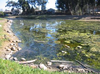
Figure 3.7 Algal Blooms on the Surface of Moran Lake when the Lagoon is Non-Stratified with Little or No Flow from Freshwater or Tidal Inputs – October 28, 2003
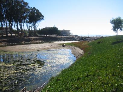
Figure 3.8 Moran Lake when the Lagoon is Non-Stratified with Little or No Flow from Freshwater or Tidal Inputs and the Lagoon is Primarily Filled with Saline Water– October 28, 2003
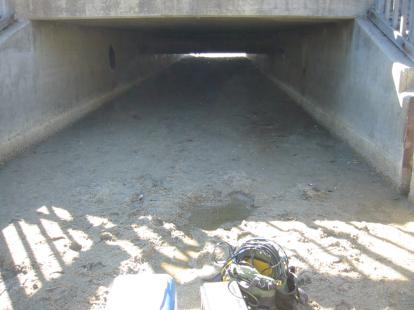
Figure 3.9 Moran Lake Box Culvert Closed with Sand– October 28, 2003
3.2.2 Watershed Modifications and Hydrology
Moran Creek and Drainage Modifications
The primary stream or drainage channel in the watershed is Moran Creek. Moran Creek is an intermittent stream, approximately 12,295 feet long, with an approximate slope of 0.6%. Approximately 6,395 feet of the channel is above ground, but is characterized by reduced riparian corridor width and discontinuous, mixed vegetation with a large non-native component. Approximately 5,900 lineal feet of channel has been collected below ground in culverts installed beneath roads and residential and commercial properties. Today most of the stream channel and riparian corridor has been encroached upon by urban development and the channel is confined to a very narrow channel. Only a few reaches of the stream remain in a relatively natural condition.
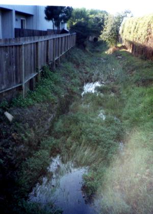
Figure 3.10 Moran Creek—Open Channel with Urban Encroachment
According to the County of Santa Cruz Storm Water Master Plan and Management Program, the Moran Lake watershed is approximately 546 acres in area (KVL, 1998). Urbanization in the watershed has included the installation of a complex drainage network that drains many of the developed lands to Moran Lake. With the shift from rural agricultural land use, runoff rates and volumes to the existing drainage systems have increased. To compensate for these changes the county and state have modified and reduced the drainage area of the watershed. With the construction of Highway One and development projects in the upper watershed areas, a substantial portion of the drainage area has been redirected to Rodeo Gulch and Soquel Creek.
Even with the reduction of the watershed drainage basin, continued urbanization has resulted in localized flooding in some portions of the watershed. To mitigate flood problems in the lower watershed, the County constructed the 38th Avenue Stormwater Detention Basin (Basin), as shown in Figure 3.11. The Basin is located on the southeast corner of the intersection of Brommer Street and 38th Avenue, and receives runoff from approximately 235 acres in the upper Moran Lake watershed. The Basin is designed to temporarily store runoff resulting from events that exceed the 150 cubic feet per second (cfs) capacity of the downstream culvert.
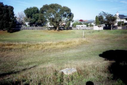
Figure 3.11 38th Avenue Stormwater Basin
Based on discussions with local residents some reaches of the stream continue to experience localized flooding. These events are primarily attributed to older infrastructure projects, such as undersized culverts that have not been replaced to accommodate increased runoff rates. Ongoing development in the watershed continues to contribute to these problems.
Effects of Urbanization on Watershed Hydrology.
Land use within the Moran Lake watershed includes single family residences, shopping centers and commercial development, grassland, and mobile home parks. It is estimated that approximately 95% of the watershed has been urbanized with a substantial amount of impervious surface coverage. The increased impervious surface has dramatically altered the natural runoff patterns (hydrograph) and groundwater recharge in the watershed. Impervious surfaces, such as roads and parking lots, do not allow rainfall to infiltrate into soil, and shed it to drainage courses in a shorter period of time and at a higher volume than compared to a natural or landscaped area. As groundwater infiltration is reduced, flooding potential increases. Figure 3.12 shows changes that occur as a result of urbanization. As can be seen in the graphs the hydrograph for the urbanized area is much steeper and occurs over a shorter period of time indicating that the lag time between precipitation events and peak stream flows occurring in a stream has been shortened and the peak runoff flow and volume have increased.
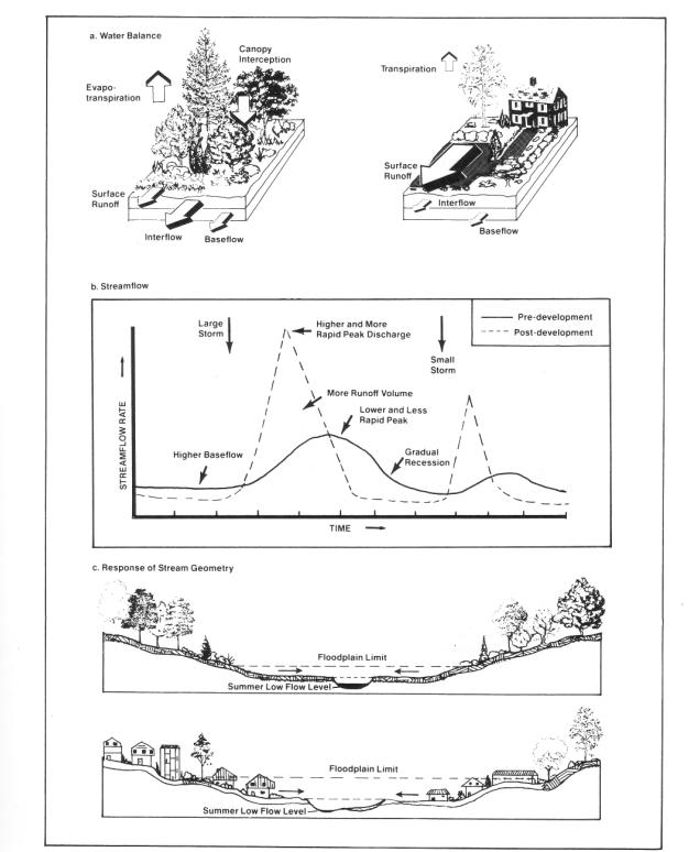
Figure 3.12 Typical Changes in Watershed Hydrology as a Result of Urbanization
Urban development reduces or eliminates natural rainfall storage within a watershed area. Natural storage areas include trees that intercept rainfall, depressions on the ground surface, and porous surface soils. When these areas are removed due to development activities, the rainfall storage capacity is reduced and rainfall is more quickly converted to runoff. Runoff rates are further accelerated when construction includes impervious surfaces such as rooftops, roads, parking lots, sidewalks, and driveways. Alterations to natural rainfall runoff patterns also change stream hydrology. Impacts to stream hydrology associated with urban streams, such as Moran Creek, can be summarized as follows: Increased Flooding. The first change in stream hydrology in urban streams is an increased magnitude and frequency of severe floods. It has been estimated that peak discharges in urban watersheds increase two to five times from pre-development levels. The higher magnitude flows occur because natural storage and infiltration areas are reduced or eliminated, increasing the volume of water entering an urban stream channel. The frequency of severe flooding increases because flow magnitudes are higher in urban streams. For example, a flow that would be expected to occur once every two years in an undeveloped watershed can occur as often as three or four times a year in an urban stream.
Increased Flooding.
The first change in stream hydrology in urban streams is an increased magnitude and frequency of severe floods. It has been estimated that peak discharges in urban watersheds increase two to five times from pre-development levels. The higher magnitude flows occur because natural storage and infiltration areas are reduced or eliminated, increasing the volume of water entering an urban stream channel. The frequency of severe flooding increases because flow magnitudes are higher in urban streams. For example, a flow that would be expected to occur once every two years in an undeveloped watershed can occur as often as three or four times a year in an urban stream. Increased Bank Erosion and Sedimentation. The second change in stream hydrology is an increased frequency of erosive bankfull and sub-bankfull floods. A bankfull flow occurs once every 2 to 2.5 years and has the greatest influence on channel forming features, such as bank height and location and mid-channel bars. The frequency of a bankfull or sub-bank full flow increases in an urban watershed, causing high energy flows that disrupt the channel equilibrium, accelerating bank and channel erosion and sedimentation in the downstream stream and lagoon. Increased bank erosion can also result in costly damage and/or loss of private and public property and infrastructure. Figure 3.13 shows active bank erosion occurring in the upper stream reach of Moran Lake.
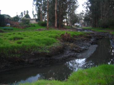
Figure 3.13 Channel Erosion in Upper Reach of Moran Lake
Groundwater Recharge.
The third change in stream hydrology is reduced groundwater recharge. Surfaces such as sidewalks, roads, rooftops, and driveways cover areas that once would have absorbed or infiltrated rainfall. The decreased infiltration capacity in urban watersheds decreases the extent of groundwater recharge, and will therefore reduce stream baseflow during dry weather. It is likely that prior to urbanization in the watershed, stream flow in Moran Creek was higher throughout the year (except immediately following storm events).
Loss of Habitat.
Urbanization and channelization has substantially reduced the extent of natural habitat along Moran Creek. The loss of natural habitat impacts wildlife and limits future restoration and recreational opportunities in the watershed.
Loss of Flood Plain.
Development and covering of the creek has resulted in the loss of the natural floodplain of Moran Creek. In a natural setting a stream is bordered by a floodplain that is periodically inundated when stream flows overtop channel banks. Reducing the width of the stream and confining it to a narrow band prevents the stream from accessing the floodplain, increasing the frequency of flooding and forcing high energy flows to remain in a narrow channel that accelerates channel downcutting and bank erosion.
1. The size of the lagoon has been significantly reduced and confined to a small area as a result of dredge material disposal, development and infrastructure projects surrounding the lagoon. These modifications have restricted the natural geomorphic changes that would naturally occur in a coastal lagoon in response to episodic storm events, and have limited the expansion of the lagoon onto the beach west of East Cliff Drive.
2. Preliminary review and analyses indicate that the existing box culvert under East Cliff Drive may be slightly undersized to handle the full tidal prism entering and exiting the lagoon; however, beach profile monitoring at the mouth of the lagoon suggest that the box culvert is not a substantial barrier to flushing. Substituting a bridge or adding a new culvert may not produce significant changes to winter or summer lagoon conditions. This is due to the relatively small lagoon size, rapid formation of the sand bar, and altered runoff volumes from the watershed. Lowering the culvert depth to –2 to -3 feet below MSL may also allow greater water exchange, particularly at low tides, but could cause additional bank erosion and damage to public or private property. If either change is considered, possible effects of increased salinity on lagoon aquatic and upland wildlife habitats must also be reviewed. A more extensive hydraulic modeling study would be required to determine if replacing the culvert with a clear span bridge or arched culvert would substantially improve water circulation and water quality in the lagoon.
3. Urban land use within the Moran Lake watershed has altered the surface water hydrology of Moran Creek. The increased impervious surface has dramatically altered the natural runoff patterns (hydrograph) and groundwater infiltration in the watershed.
4. The change in stream hydrology has increased the frequency of erosive bankfull and sub-bankfull floods, and has accelerated bank and channel erosion and sedimentation in the stream and lagoon. These changes can result in costly damage and/or loss of private and public property and infrastructure.
5. Development in close proximity to the creek, and undergrounding the creek has resulted in the loss of the natural floodplain of Moran Creek. Reducing the width of the stream and confining it to a narrow band prevents the stream flow from accessing the floodplain, increasing the frequency of flooding and forcing high energy flows to remain in a narrow channel that also accelerates channel downcutting and bank erosion. Urbanization and channelization has also substantially reduced the extent of natural habitat along Moran Creek. The loss of natural habitat impacts wildlife and limits future restoration and recreational opportunities in the watershed.6. In some reaches below the 38th Avenue detention basin some existing culverts on Moran Creek are undersized resulting in localized flooding during peak storm events. More detailed hydraulic analyses would be required to assess the extent of flooding and to determine an appropriate solution to improve conditions along the stream.