


Moran Lake Water Quality Study & Conceptual Restoration Plan
Prepared For:
Santa Cruz County Redevelopment Agency
701 Ocean Street, 5th Floor
Santa Cruz, CA 95060
Prepared
By:
John Gilchrist & Associates
&
Fall Creek Engineering, Inc.
March 2005
1.
Executive Summary & Introduction.........................1-1
1.1 Executive
Summary.............................................1-1
1.2
Introduction.......................................................1-3
1.2.1
Background.......................................................1-3
1.2.2 Public Concerns and Issues..................................1-3
2.
Setting...................................................................2-1
2.1 Regional
Setting..................................................2-1
2.2 Natural
History....................................................2-1
2.2.1 Geology.............................................................2-1
2.2.2 Hydrology..........................................................2-3
2.2.3
Biology..............................................................2-3
2.3 Historic and Present Watershed Boundaries............2-6
2.4 Jurisdictional Boundaries......................................2-6
2.5 Land Use...........................................................2-6
3. Lagoon and Watershed History.......…………………….3-1
3.1
Historic Drainage and Morphology…….......…...…………..3-1
3.1.1 Lagoon Hydrology Prior to Yacht Harbor
and Coastal
Development...................................3-1
3.1.2
Watershed Hydrology and Drainage System..……………3-4
3.2 Current Drainage and
Morphology…………………………..…..3-4
3.2.1
Lagoon Hydrology............…………………………………..……..3-4
3.2.2
Watershed Modifications and Hydrology.………...………..3-11
3.3 Summary and Conclusions.....………………………..……………3-16
4. Water
Quality……...…………………………….…………...4-1
4.1 Overview
……………………………….........…………………………...4-1
4.2. Review of Historical Water Quality Studies
and Monitoring
Activities…………………………………….………4-2
4.3. Water Quality
Monitoring....…………………………………………4-4
4.3.1
Methodology …………..............………………………………………4-5
4.3.2
Results and Field Observations...…………………………………4-7
4.4
Summary of Findings....…………………………………………………4-37
5.1 Lagoon Restoration and Education Opportunities.…..…5-1
5.1.1 Improve Lagoon Water Circulation ……….....…………………5-1
5.1.2 Create Wetlands in Upper Lagoon ……….....…………………5-6
5.1.3 Reshape Bank Slopes and Restore Lagoon
Fringe Wetlands ………..............…………………………………5-8
5.1.4 Remove Non-Native Plants and Restore with Native
Wetland and Upland Species< ……………….....…………………5-10
5.1.5 Interpretive Trail and Signing.......…………………………………5-11
5.2 Watershed Restoration Options………………………………………5-12
5.2.1 Water Treatment Wetland at 38th Ave Detention Basin.5-12
5.2.2 Restore Moran Creek Riparian Corridor........…………………5-13
5.3 Storm Water Management and Treatment ……….……………5-15
5.3.1 Innovative Sight Design...............…………………………………5-15
5.3.2 Storm Water Control and Treatment BMPs....…………………5-16
5.3.3 Performance Standards for Storm Water Management..…5-16
5.4 Public Education and Outreach ……………………………..…………5-28
6. Implementation………………………………………….…….6-1
6.1
Planning and
Implementation...………………………………….………6-1
6.1.1
Funding…………………………………………………...........................6-1
6.1.2 Restoration Project Implementation…….………….………..……..6-1
6.1.3 Public Education and Programmatic Activities
……….………..6-2
6.2
Project Cost Analysis...…………………………………………….…….....6-3
6.2.1 Replacement of the East Cliff Drive Box Culvert with
an Arched, Bottomless Culvert ……………….....…………….....6-4
6.2.2 Upper Lagoon Wetland ………………………………………..............6-6
6.2.3 Reshape and Stabilize Lagoon Bank…..............…....….....6-7
6.2.4 Modify 38th Avenue Detention Basin with
a Low-flow Wetland
………….........………….……..……………...6-8
6.2.5 Restore Moran Creek Corridor....….….….….…..…….…..…….….6-9
6.2.6 Removal of Non-native Invasive Plants and
Revegetation with Natives...…..…..…..….…....…..….….…..6-10
6.2.7 Intrepretative
Signs……..….…..…..….….…..….…..….……….….…6-10
6.3 Constraint Analysis ..…..……….….….…….…….…..……….………..
6-10
Appendix A - Stormwater Best Management Practices (BMP's)
LIST OF FIGURES
Figure 2.1 Vicinity
Map of Moran Lake - Santa Cruz County
Figure 2.2 Pre and Post Development
Watershed Areas - Moran Lake
Figure 2.3 Moran Lake
Jurisdictional Boundaries
Figure 2.4 Arial photo of Moran
Lake taken April 1, 1931
Figure 2.5 Arial photo of Moran
Lake taken August 23, 1953
Figure 2.6 Arial photo of Moran
Lake taken March 26, 1986
Figure 3.1 Moran Lake Beach
Profile, 2001-2002 Season
Figure 3.2 Summary of Conductivity
and Salinity Measurements Collected
During the First Flush Event on October
31, 2003 from Site 2
Figure 3.3 Moran Lake After
Ephemeral Bar has Breached and
Lagoon is
Partially Mixed – November 12, 2003
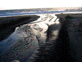
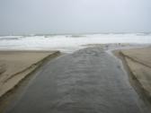
Figure 3.4 Moran Lake Beach After Ephemeral Bar has Breached and Lagoon
is
Partially Mixed – November 12, 2003
Figure 3.5 Lagoon Outflow Non-Stratified with Primarily Freshwater Flow
– February 2, 2004
Figure 3.6
Moran Lake when the Lagoon is Non-Stratified with Primarily Freshwater Flow - February
2, 2004
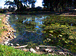
Figure 3.7 Algal Blooms on the Surface of Moran Lake when the Lagoon is Non-Stratified with Little
or No Flow from Freshwater or Tidal Inputs – October 28, 2003
Figure 3.8 Moran Lake when
the Lagoon is Non-Stratified with Little or No Flow from Freshwater or
Tidal Inputs and the Lagoon is Primarily Filled with Saline
Water–October 28, 2003
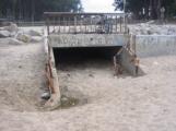
Figure 3.9
Moran Lake Box Culvert Closed with Sand– October
28, 2003
Figure 3.10
Moran Creek
Figure 3.11
38th Avenue Stormwater Basin
Figure 3.12
Changes in Watershed Hydrology as a Result of Urbanization
Figure 3.13 Channel Erosion in
Upper Reach of Moran Lake
Figure 4.1
Moran Lake Sampling Locations
Figure 4.2 Sampling Location #4,
Moran Creek East of 30th Avenue
Figure 4.3 pH in Moran Lake (June
26, 2003 to October 31, 2003)
Figure 4.4.1 Dissolved Oxygen Concentrations at Lagoon Inlet (Site 1)
Figure 4.4.2 Dissolved Oxygen Concentrations at Site 2
Figure 4.4.3 Dissolved Oxygen Concentration at Site 3
Figure 4.4.4 Dissolved Oxygen Concentration in Moran Creek
Figure 4.5 Morning and
Afternoon Dissolved Oxygen Concentrations
Figure 4.6 Water Temperature
(Degrees oC) Measured at Sites 1 and Site 4
Figure 4.7 Nutrient
Concentrations at Site 2 on October 28 and October 31, 2003
Figure 4.8 Results of Fecal
Coliform Counts on August 12 and October 31, 2003
Figure 4.9 Total Suspended Solids
Concentrations
Figure 4.10 Turbidity Measurements
taken on August 12th and
October 31st 2003
Figure 4.11 Salinity Measurements
Collected at Site 1
Figure 4.12 Salinity Measurements
on June 5th, July 25th,
September 30th, 2003
Figure 4.13 Salinity and
Conductivity Measurements at Site 2 on October 31, 2003
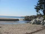
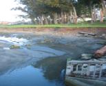
Figure 5.1 Moran Lake Outlet
(September, 2002)
Figure 5.2 Corcoran Lagoon
(September, 2002)
Figure 5.3 Examples of Bottomless
Arched Culvert Crossings
Figure 5.4 Public Land in
Upper Lagoon Identified for Possible Wetland Development
Figure 5.5 Conceptual Layout of
Proposed Wetland in the Upper Lagoon Area of Moran Lake
Figure 5.6 Cross-Section of
Restored Wetland Area
Figure 5.7 Eroding Bank on the
Eastern Shore of Moran Lake
Figure 5.8 Cross-Section showing
the Conceptual Layout of Restored Bank on Eastern Shore of Moran Lake
Figure 5.9 Possible Location for
Revegetation with Native Plant Species
Figure 5.10 Example of Interpretive
Sign
Figure 5.11 Conceptual Layout of 38th
Avenue Detention Basin Modified to Include a Stormwater Wetland
Figure
5.12
Conceptual Layout of Moran Creek Stream Restoration
LIST OF TABLES
Table 4.1 pH Field Measurements
Table 4.2 Dissolved Oxygen Concentration (mg/L) Measurements
Table 4.3 Temperature Field Measurements (Degrees Centrigrade, oC)
Table 4.4 Nutrient (Nitrogen and Phosphorus) Measurements (in mg/L)
Table 4.5 Total and Fecal Coliform Measurements
Table 4.6 Turbidity (in NTU) and Total Suspended Solids (in mg/L) Measurements
Table 4.7 Salinity Field Measures (in parts per thousand, ppt)
Table 4.8 Conductivity Field Measurements (in micron siemens, mS)
Table 4.9 General Mineral Analysis
Table 4.10 Total Copper, Lead and Zinc Concentrations (all in units ug/L)
Table 4.11 California Toxics Rule (US EPA Water Quality Criteria) for the
Protection of Freshwater
and Saltwater Aquatic Life
Table 4.12 Water Quality Objectives from the Central Coast Region Water Quality
Control Plan
Table 4.13 Comparison of Moran Creek and Lagoon Water Quality to Urban Runoff
Water Quality in
Other Areas
Table 4.14 Sediment Quality Test Results - November 25, 2003
Table 4.15 Comparison of Moran Lake Sediment Quality to Other Areas
Table 6.1 Preliminary
Cost Estimate for Arched Bottomless Culvert for East Cliff Drive Crossing
Table 6.2 Preliminary Cost Estimate for Wetland in Upper Lagoon
Table 6.3 Preliminary Cost
Estimate for Bank Stabilization Project on east side of Lagoon
Table 6.4 Preliminary
Cost Estimate to Modify 38th Avenue Detention Basin with a Low-Flow
Wetland
Table 6.5 Preliminary Cost
Estimate for 1000 feet of Channel Restoration
Table 6.6 Cost Estimate for
Non-Native Plant Removal and Revegetation
Table 6.7 Costs for
Interpretative Signs and Trails
Table
6.8
Benefits and Constraints Analysis
1. Executive Summary & Introduction
1.1 Executive Summary
Moran Lake is a coastal lagoon located in the Live Oak Area of Santa Cruz County that seasonally connects to Monterey Bay. The Moran Lake watershed has been modified as a result of development and land use changes in the area. Increased impervious surfacing has decreased infiltration capacity and increased the volume of water entering Moran Lake and its principal tributary, Moran Creek. Roads, parking lots, commercial and residential land uses have contributed to impaired water quality within the watershed and in Moran Lake. Water and sediment sampling and testing conducted in this and previous studies have documented problems concerning water quality and low biologic productivity in Moran Lake. However, the Lake and its surrounding uplands also support two sensitive species, the tidewater goby and monarch butterfly. Presence of these species must be considered in any lake restoration planning. Vegetation in wetland and upland areas around the lagoon consist primarily of non-native trees, shrubs and herbaceous species. Blue gum eucalyptus is the dominant tree species, and is an important resource for the over-wintering monarch butterfly population. Wildlife surveyed during previous studies included relatively common shore birds, water birds and upland bird and mammal species. Numbers of water-associated wildlife species are lower than nearby lagoons such as Corcoran due to reduced aquatic productivity in Moran Lake.
Moran Lake, like other coastal lagoons, is a body of brackish or saline water impounded by a barrier beach, with a seasonal inlet/ outlet. The size and shape of the lagoon, inlet configuration, watershed drainage and other environmental factors influence the chemistry, water circulation and ecology of a lagoon under natural conditions. Moran lagoon has been altered by artificial fill, reducing its size from nine to five acres in the early 1960’s, and by constriction of the inlet with a culvert at East Cliff Drive. The 7-foot diameter culvert was replaced by a larger box culvert in 1981. Although culvert replacement increased water exchange, these changes have confined the lagoon to a relatively fixed configuration, with some limitation on ocean – lagoon water interchange. The box culvert may be slightly undersized to handle the full tidal prism and streamflows entering and exiting the lagoon. However, due to presence of a barrier beach and the current reduced lagoon configuration, replacing the culvert with a bridge or arch culvert may not produce significant changes to winter or summer lagoon conditions. In summer months hyperhaline conditions (high salinity), and algal blooms indicative of a eutrophic water body are prevalent in Moran Lake. During the 2004 study period, streamflow into the Lake was small compared to winter months. Lake bank erosion is a problem during higher winter runoff periods.
Because Moran Lake water quality concerns were the focus of this study, baseline water quality monitoring was undertaken at four locations between June and October 2003. In addition, lagoon sediments samples were collected and analyzed at several water sampling locations in November 2003. Fecal coliform contamination continues to be a problem in the lagoon with likely sources that include leaking sewers, domestic animals and wildlife. Nutrients, including total phosphorus, nitrate and ammonia were reasonably low during summer months, but were elevated after the “first flush” rainfall event in late October. Sources include urban pollutants such as waste products and fertilizers. Dissolved oxygen levels were low and then relatively high in morning and afternoon sampling which is typical of a eutrophic lake with urban pollutants and large algal blooms. Presence of high concentrations of sodium and chloride in late summer was expected due to hyperhaline conditions in the lake. The concentration of trace metals varied significantly both spatially and seasonally, with highest levels taken from the Moran Creek station and during the “first flush” rain event. Copper and zinc were present at potentially toxic levels. Sediment samples detected the presence of several polyaromatic hydrocarbons (PAHs), commonly known as oils and grease. Principal sources of PAHs are roads, parking lots and vehicle service areas. Several of the PAH compounds detected are carcinogenic and other compounds are potentially detrimental to aquatic life. Sediment testing for organochlorine pesticides and PCB’s detected only the pesticide chlordane above threshold levels. This persistent pesticide may also adversely affect aquatic life. Water and sediment sampling yielded results that were generally similar to previous water quality testing for Moran Lake, but some contaminant levels were less than those found in other urban watersheds in the San Francisco Bay area.
Restoration opportunities exist in the Moran Lake watershed to improve water quality and habitat conditions in the lagoon. Many opportunities exist in the immediate vicinity of the lagoon, while other projects and actions can be taken in the upper watershed area.
Restoration options include a broad spectrum of activities, including physical restoration projects, storm water management and treatment, recommendations for environmental education, site planning and design standards with the objective of reducing impervious cover in the watershed. Specific Moran Lagoon restoration options include modifying the lagoon inlet-outlet with a bridge or arched culvert to improve ocean-lagoon water exchange, although as noted, the presence of a barrier beach and the current reduced lagoon configuration may limit water quality improvement. The lagoon could also be dredged and expanded, artificially aerated, and/ or artificially breached, although there are constraints to each of these options. Upper watershed streamflow could be augmented with treated wastewater from a small treatment plant at Lode Street, however there are environmental and public perception issues associated with this alternative. There is an opportunity to create a ‘treatment wetland’ on public lands in the upper lagoon that could improve lagoon water quality and wildlife habitat. Other restoration options at Moran Lake include bank replacement and revegetation of the eroded east slope, removal of exotic plant species and revegetation with natives, and interpretative signing on park trails to inform the public about Moran Lake resources.
Restoration in the upper watershed can also improve Moran Lake water quality. Modification of the 38th Avenue Flood Detention Basin to accommodate a treatment wetland would reduce nutrients, bacteria and heavy metals contained in upper Moran Creek watershed urban runoff. The treatment wetland design would need to insure equivalent flood management currently provided by this facility. There are also opportunities to restore portions of Moran Creek to a functional riparian corridor. A restored flood terrace and native riparian vegetation can reduce upstream pollutant loadings. Storm water management and treatment practices are also available to reduce pollutants from the urban watershed. Source control and treatment best management practices (BMP) are discussed in Chapter 6 and Appendix A. These include innovative site design practices for new development, storm water treatment devices including drainage inlet filters, bioretention swales and constructed wetlands, and implementation of performance standards for storm water management. Finally, public awareness of maintaining good water quality in Moran Creek and Lake can be developed with informational brochures and volunteer watershed stewardship organizations. Prioritization and cost estimates for these restoration measures are set forth in Chapter 6 of this report.
1.2 Introduction1.2.1 Background
Moran Lake, one of several coastal lagoons in unincorporated Live Oak, is located near East Cliff Drive in the Pleasure Point area. Previous studies and water quality monitoring have documented problems concerning water quality and low biologic productivity in the Moran Lake lagoon. These same studies have proposed drainage and water quality improvements in the lagoon and upper watershed.
Spoils from Yacht Harbor dredging were used to fill Moran Lake in the early 1960’s reducing the size of the lagoon by over 3 acres. In 1981 a box culvert replaced a smaller culvert allowing increased tidal exchange and flushing of lagoon waters. At the same time, a paved parking lot and restrooms were constructed on part of the Harbor fill sediments and the Lake and adjacent uplands began to be managed by the Santa Cruz County Parks, Open Space and Cultural Services Department. Urbanization in the watershed upstream of the lagoon has increased significantly over the last 35 years, causing drainage and water quality problems for the upstream watercourse, Moran Creek, and for Moran Lake.
1.2.2 Public Concerns and Issues
Since 2001 a group of Live Oak neighbors expressed concerns regarding Moran Lake to Santa Cruz County Public Works, Planning and Redevelopment Departments, County Parks Commission and the Board of Supervisors. Specific concerns included the restriction of tidal flow caused by the box culvert, recent rip-rap installation at the culvert, decrease in lake water quality caused by impervious surfaces and polluted runoff from the watershed, and problems associated with lagoon fill from 1960’s harbor dredging. The neighborhood group has asked the County to consider replacing the culvert with a bridge in order to restore tidal exchange and flushing of the lagoon. The group has also expressed concerns regarding expansion of the rip-rap at the outlet and continued deterioration of lagoon water quality from urban land uses in the watershed.
1.2.3 Scope of Project & Project Objectives
Previous studies that described Moran Lake as an impaired water body are over 25 years old. Because changes in the watershed and lagoon itself have occurred over the last 25 years, it is not clear whether water quality problems continue as previously observed in Moran Lake, and if so, the severity or magnitude of the problems.
To address these concerns and to update historical information, the Santa Cruz County Redevelopment Agency (RDA) agreed to undertake a baseline study to assess current conditions. The RDA retained John Gilchrist and Associates to conduct this baseline study. The objectives of the project are as follows:
Obtain water quality data over a
5-6 month period that will provide information on current lagoon conditions·
Develop a better understanding
of lagoon hydrology by reviewing watershed inflows, tidal exchange and lagoon
configuration in order to assess potential for water quality improvement options
and other lagoon/ watershed management opportunities.
Review existing biologic information, including data on species of concern, to better understand the
interactions between lagoon hydrology, water quality and biology, and recommend
possible lagoon enhancement options.
Provide recommendations on
future focused studies or design work needed to implement restoration and
enhancement options.
This report presents the results of the baseline study. The document is divided into the following technical sections:
Section 2 - Setting. This section provides an overview of the Moran Lake and watershed setting, including a description of the natural history (geology, hydrology, and biology), historic and present watershed boundaries, jurisdictional boundaries, and land use changes over several decades.
Section 3 - Lagoon and Watershed Hydrology. This section provides a detailed description of the historical and current drainage and morphology of the lagoon. It also provides a description of the hydrologic conditions in the upper watershed areas. Emphasis is placed on the effects that modifications to the lagoon and the watershed have had on the function and conditions of the lagoon and watershed hydrologic processes.
Section 4 – Water Quality. This section provides a review of historical and recent water quality studies of Moran Lake, and presents the results of water quality and sediment testing undertaken as part of this study.
Section 5 Restoration Options. This section provides conceptual restoration opportunities in the Moran Lake watershed to improve water quality and habitat conditions in the lagoon. Restoration options presented include a broad spectrum of activities, including physical restoration projects, storm water management and treatment, recommendations for environmental education, and site planning and design standards to improve watershed conditions and reduce impervious cover.
Section 6 – Implementation. This chapter provides a general review of planning and implementation activities for each restoration option. Also included are cost estimates for the projects and a preliminary constraint analysis that reviews benefits and constraints for each project. Projects receive a preliminary ranking based on this constraint analysis.
Section 7 – Report References.
Appendix A – Stormwater Best Management Practices